Reported (mostly) by Dan Ralston
Iva Gillet led the hike assisted by Dan Ralston as co-lead on his first leader-in-training hike. The location for today’s adventure was west of Amherst
Wildflower enthusiasts, a phrase that describes all the women in the group, hit the jackpot on this hike. Iva spotted a lovely showy orchis early on, and soon we were seeing lots of them. Wild azalea, wild geraniums, squawroot, lush ferns, and lots of flowers that we admired but did not identify (Michael Seth, where are you?) grew in the area.
 |
| Yellow lady's slippers |
 |
| Barbara Martin photographing flowers |
The most exciting flower-find of the day: the rare yellow lady’s slipper. Shortly before reaching the forest road in the afternoon, Marian Styles and Barbara Martin saw two of them growing right beside the trail, and we spotted a handful more on the opposite side of the trail. The faster hikers didn’t completely miss out because we later saw a few more of the spectacular flowers off the road and beside the stream.
As if the wildflower bonanza weren’t enough, history buffs were rewarded with seeing a site along Brown Mountain Creek of an old settlement where freed slaves once lived.
In the wildlife department, we admired several Red Efts, which were really more orange with colorful spots on their backs. Bill Holman rescued one from the forest road.
Speaking of Bill, both he and Dan are new members of the PATC Rangers Division. During today’s hike, they surveyed the hiking loop with GPS’s and pictorial landmarks for accuracy confirmation, and the results will be used for the revision of PATC Map 13 in a couple of years.
 |
| Lunch at Brown Mt Shelter |
 |
| Removing some blowdowns with bare hands and clippers |
While having lunch at the Brown Mountain Creek AT Shelter, we were joined by a through hiker who started in February from
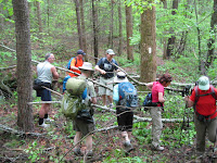
In the trail maintenance department, some of us cleared a couple of blowdowns along the route, with bare hands, no less.
Just as Dan had predicted before the hike, the forecast rain never came. We capped off a lovely day with a stop for ice cream, and some folks continued the good times at the Timberwood Grill.
 |
| Another group of yellow lady's slippers |
 |
| Red eft |
In addition to those already named, also hiking were John Shannon, John Brandt, Rich Bard, Page Williams (Iva's cousin), Brian Muszynski, and Ken Moss. We covered 7.4 to 8.4 miles, depending on whose GPS we used (Bill’s, Dan's, Ken's or John Shannon's)—although Ken's and John's did match to around 8 miles because they were using the same model.


No comments:
Post a Comment